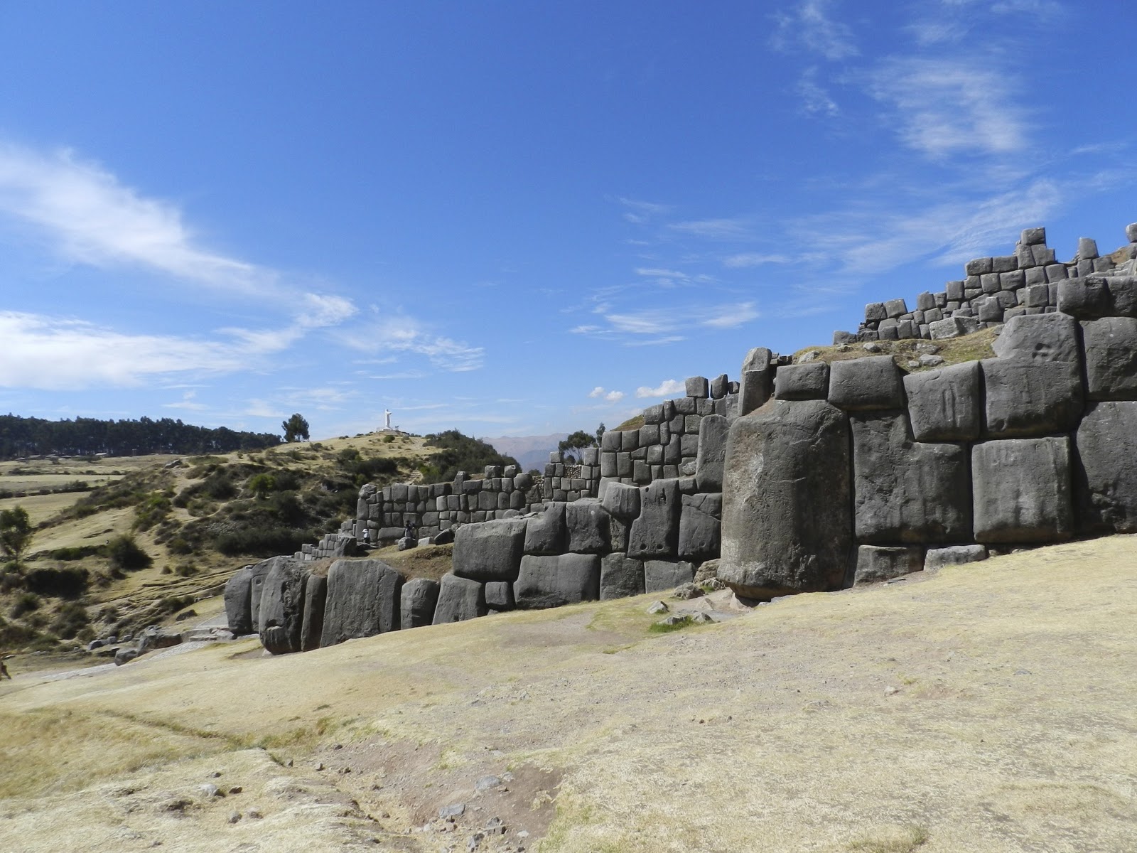
Next post will return to fabled Inca cities I visited in Peru
October 2011
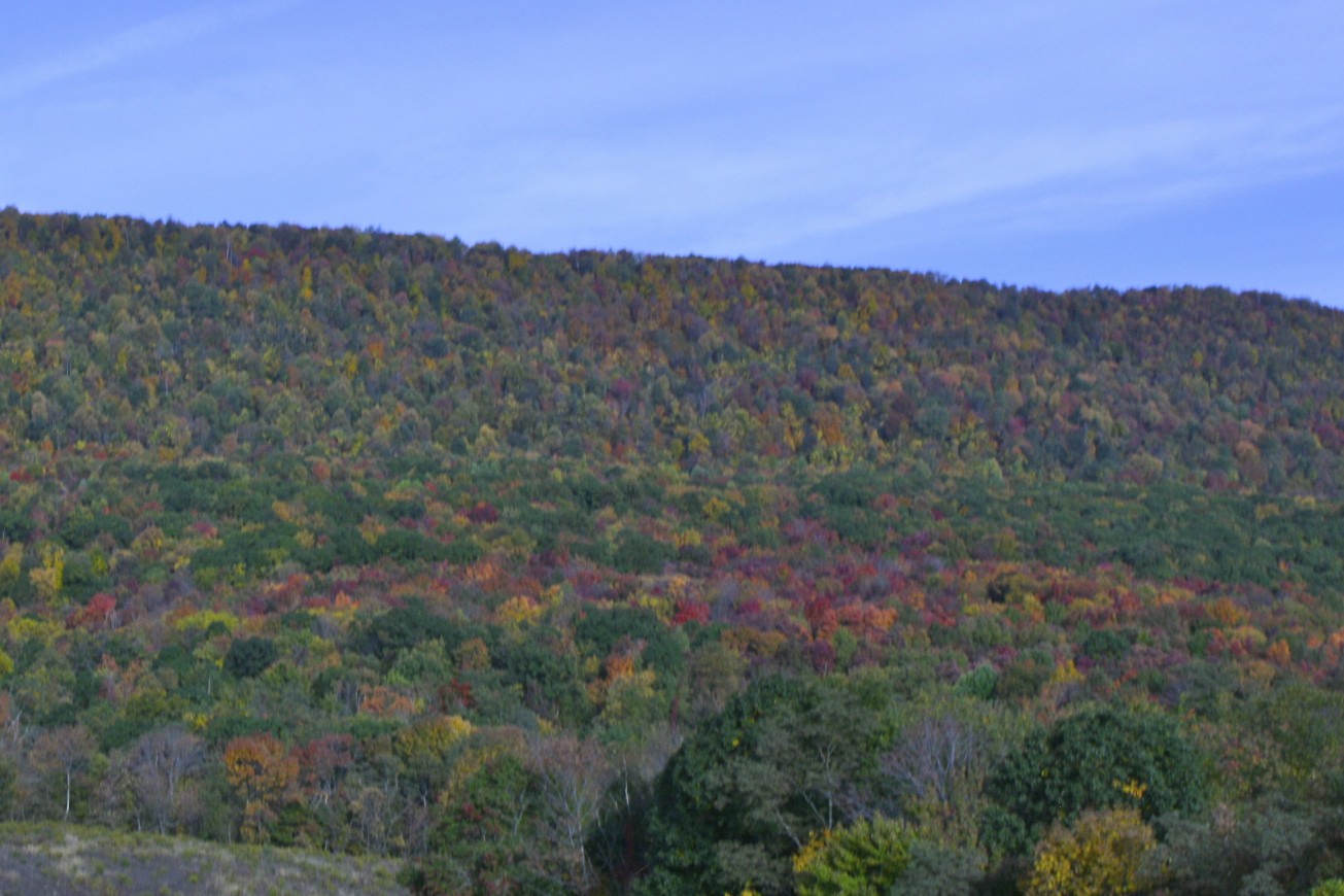
When some friends were in town over the Columbus Day weekend, they wanted to visit the newly dedicated memorial for the victims who died September 11, 2001 on United Flight 93 near Shankstown, Pennsylvania. So very early in the morning, we headed northwest on Maryland's highways into hills shrouded in eerie fog and mists. As the sun started to clear away the fog, it revealed the brilliant colors of trees starting to put on their fall wardrobe of yellows, oranges, and reds. There was a pleasant crispness to the air that reminded us that the intense heat of the summer would not return for many months.

Our GPS led us through prosperous farms, tiny towns, and beautiful woods as we wound our way through Western Pennsylvania. Then suddenly, in the midst of this peaceful place, we came to the entrance to the memorial dedicated to those brave Americans who, realizing their plane was to be used as a bomb by terrorists to destroy more lives, chose to fight back and end their lives in this lonely field.

According to the chronology given at the site, Flight 93 left Newark, New Jersey for San Francisco after a 25 minute delay due to air traffic. The Twin Towers were attacked four minutes later; Flight 77 crashed into the Pentagon a half hour later. All US aircraft were ordered to land, but the hijackers had already taken control of the plane and turned it toward Washington, DC. The crew and passengers of Flight 93 had been herded to the back of the plane where they secretively reported the hijacking through cell phones. Hearing of the other attacks and realizing they would probably be used to attack the nation's capital, they did the American thing--took a vote and made a plan. They resisted their guards, attempted to storm the cockpit, and called loved ones on cell phones to share their final thoughts. According to the black box that was recovered, they never made it into the cockpit, but the hijackers were rolling the plane to thwart the passengers.

The plane was upside down when it flew over the hill and then plunged head first into a field in the Stonycreek Township at 563 miles per hour. Many citizens of Shanksville (2 miles away) and surrounding areas realized something was terribly wrong when they saw the plane fly over. First responders were at the site within minutes of the crash, but there were no survivors to save--only fire and smoke. It soon became apparent that the plane was likely headed for the U.S. Capitol and that it had been part of the planned attack on America that infamous day.
On the morning of September 11, as I watched in disbelief as the Twin Towers and then the Pentagon were attacked, I initially felt secure knowing that my parents were on a family history trip through Western Pennsylvania. Then I heard of Shanksville. While my parents were not far from the area, they were safe. Among the many lessons relearned that day, we realized how precious, yet uncertain, life is. (See Moving On post under sidebar September 11)

The memorial for the victims of this flight is still being developed, but Phase I was dedicated for the 10th anniversary on 9/10/2011. It creates a serene setting to remember the tragedy and sacrifice. From the entrance sign, one drives about 2 miles further to reach the parking lot for the memorial. They are preparing to build a larger visitor's center near the knoll that the plane flew over with other special tributes, such as a grove of trees for each victim and a place of wind chimes, symbolizing their voices. At present, there are a series of photos and explanations that one walks among before passing through a simple covered structure where you can leave comments and stamp your passport, if you thought to bring it. One then walks along a lengthly passageway which reminded me of a plane's wing, past the bolder in the field decorated with small flags where the plane hit.


A the end of the passageway is a white marble wall, consisting of slabs with the name of each victim. The wall marks the path taken by the plane before it crashed. I was moved as I read about the attack and remembered the victims. But I was also touched by the people who had come to the memorial that day. There were veterans from other wars, the elderly, the father with his young son, the injured and infirm, and other ordinary folk who all came to pay their respects to the victims as well as to affirm the strength of our nation.
Leaving the memorial, we drove through the charming town of Shanksville, hoping to find a restaurant for a late breakfast. There were no public eating places, but a kind man directed us to his favorite restaurant in nearby Somerset and shared with us his memories of seeing the plane and then the black smoke on 9-11. After a detour to see a covered bridge built in 1881, we found our way to Somerset, the county seat with its impressive courthouse.
The Kings Family Restaurant may have looked ordinary from the outside, but it was filled with friendly people and scrumptious food. Even though we were there for breakfast, I couldn't help noticing their incredible dessert menu, especially their special Double Fudgin' Trouble Sundae where some of the proceeds go to support veterans. I sure can't think of better way to support our troops than eating ice cream!
We had a delicious and filling country breakfast (though it was almost noon), and on the way out sampled their delicious berry pie and bought some of their special cinnamon bread and a box of Frownies (brownies with frosted frowns because they "make a mean dessert") which they recommend for "pity parties." I also made a contribution to the vets even though we didn't get the dessert. We took another lovely route home, hurrying to get one of our guests to the DCA airport on time for her flight at the end of a wonderful day, grateful that 10 years later, our skies were safe.
Click below for slideshow:
Flight 93 Memorial
Music: Pete Seeger,
America, the Beautiful, American Favorite Ballads, Vol. 1
More Information: http://www.nps.gov/flni/index.htm

 August is winter in Peru, so as we drove over the hills and through the valley everything was brown and barren. At first glance the countryside seemed dry and inhospitable, unable to support the growth of crops, but the promise of harvest was in the terraces that graced every mountain almost to their summits and in the fields that had been turned over, ready for planting. They grow potato, ollluco, oca, quinoa, fava beans, and barley. At the very highest levels on the mountains, they pasture their animals, the alpacas and llamas. The crop they grow there is the bitter potato. We could only imagine the green of the valley as spring and summer approached and in our minds eye, we could imagine what the ancient Incas could see. Though it was early in the morning, farmers were already in the fields, and women and young men in native dress were driving their sheep along the side of the road. We stopped at a market where vendors were eager to sell their native crafts to early tourists.


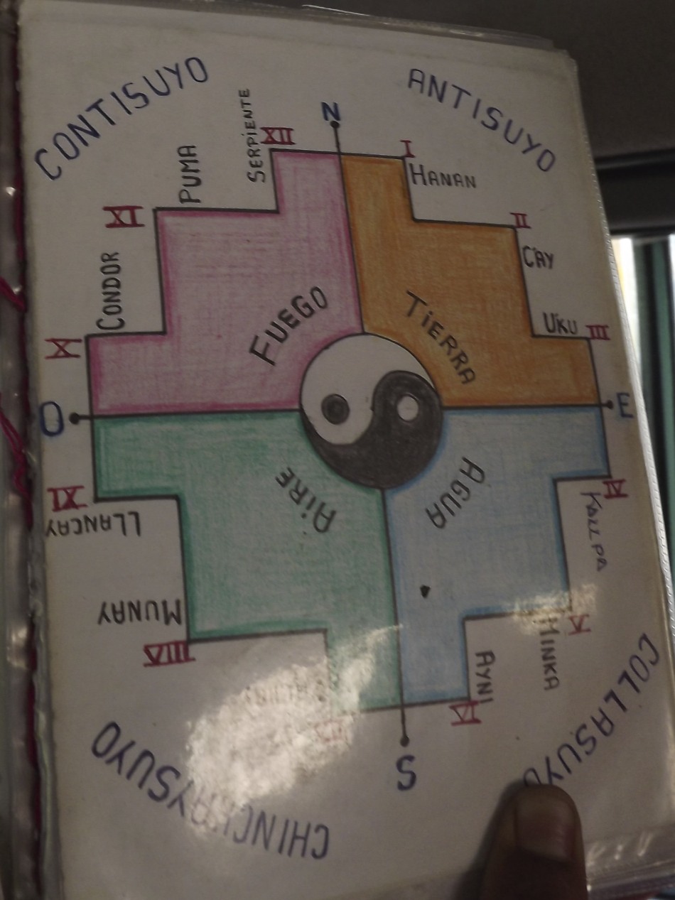
 We found a silver merchant with walls full of beautiful jewelry. I found a silver Inca cross pendant that I was looking for. Coco had explained that the Inca cross has 12 points with a circle in the center. The circle represents Cusco, the "belly button" of the world. The points represent the upper world, the gods and celestial beings (Hanan Pacha); the middle world, life here on the earth (Kay Pacha); and the lower world, the underworld and death (Uqhu Pacha). The points also represent their sacred animals, the Condor, the Puma, and the Snake. Three of the points represent their law: Don't steal; Don't lie; Don't be lazy. Three more of the points represent their principles: Love, Knowledge, and Work. The sweetest scene greeted us as we stepped out of the building. I didn't care that it was orchestrated to charm the tourists into taking pictures which required payment in Peruvian soles. Two beautiful little girls with big brown eyes were all dressed up in their native costumes, each carrying a baby llama in a sling tied around their shoulders.